St. Cloud Area Weather

Highlighting important St. Cloud MN area weather events.

Monthly Archives: October 2010

Winter Weather Advisory in effect from 10 PM-4 PM Wed… High Wind Warning still in effect until 7 PM Wed

Boy, oh boy, we are still in a mess of a storm — except a full recap later tonight or tomorrow so far — but a Winter Weather Advisory has just been issued for Stearns and Benton for a few inches of snow possible.

URGENT – WINTER WEATHER MESSAGE
NATIONAL WEATHER SERVICE TWIN CITIES/CHANHASSEN MN
357 PM CDT TUE OCT 26 2010

…BANDS OF LIGHT SNOW DEVELOPING OVERNIGHT…

.PERIODS OF LIGHT RAIN EARLY THIS EVENING ACROSS CENTRAL AND
WEST CENTRAL MINNESOTA WILL BEGIN TO MIX WITH…THEN CHANGE TO ALL
SNOW BY MIDNIGHT. DUE TO VERY WARM GROUND TEMPERATURES ACROSS THE
AREA…MOST OF THE SNOW EARLY WILL ONLY ACCUMULATE ON GRASSY
SURFACES AND ELEVATED OBJECTS. HOWEVER…ONCE SURFACE TEMPERATURES
FALL TO NEAR FREEZING OR BELOW…EXPECT THE SNOW TO BEGIN TO
ACCUMULATE ON AREA ROADWAYS.

THE WINTER WEATHER ADVISORY IS FOR AREAS MAINLY NORTH OF A LINE
FROM MORRIS TO ALBANY…FOLEY AND MORA.

TOTAL SNOWFALL ACCUMULATIONS BY WEDNESDAY AFTERNOON ONCE THE SNOW
BEGINS TO TAPER OFF WILL RANGE FROM TWO TO FOUR INCHES FROM
MORRIS…GLENWOOD AND THE SOUTH SHORE OF LAKE MILLE LACS…TO
AROUND FIVE INCHES FROM AROUND CARLOS TO LONG PRAIRIE…AND CAMP
RIPLEY. THE SNOW WILL BE COMBINED WITH VERY STRONG WINDS TO CREATE
LOW VISIBILITIES AT TIMES.

MNZ041>045-047>050-270500-
/O.NEW.KMPX.WW.Y.0013.101027T0300Z-101027T2100Z/
DOUGLAS-TODD-MORRISON-MILLE LACS-KANABEC-STEVENS-POPE-STEARNS-
BENTON-
INCLUDING THE CITIES OF…ALEXANDRIA…LONG PRAIRIE…
LITTLE FALLS…PRINCETON…MORA…MORRIS…GLENWOOD…ST. CLOUD…
FOLEY
357 PM CDT TUE OCT 26 2010

…WINTER WEATHER ADVISORY IN EFFECT FROM 10 PM THIS EVENING TO
4 PM CDT WEDNESDAY…

THE NATIONAL WEATHER SERVICE IN TWIN CITIES/CHANHASSEN HAS ISSUED
A WINTER WEATHER ADVISORY FOR SNOW AND BLOWING SNOW WHICH IS IN
EFFECT FROM 10 PM THIS EVENING TO 4 PM CDT WEDNESDAY.

* TIMING…LIGHT SNOW DEVELOPING THIS EVENING…BECOMING HEAVIER AT
TIMES OVERNIGHT…THEN TAPERING OFF WEDNESDAY AFTERNOON.

* MAIN IMPACT…LOW VISIBILITIES AND SLIPPERY ROADS.

* OTHER IMPACTS…HIGH WINDS OF 30 TO 40 MPH…WITH GUSTS TO 60
MPH.

PRECAUTIONARY/PREPAREDNESS ACTIONS…

SNOW AND BLOWING SNOW MEANS THAT VISIBILITIES WILL BE LIMITED DUE
TO A COMBINATION OF FALLING AND BLOWING SNOW. USE CAUTION WHEN
TRAVELING…ESPECIALLY IN OPEN AREAS.

All Time Low Pressure in MN Broken

And still falling, since this statement was put out Duluth has hit 28.39″… Be really interesting to see how far this does fall… Remember: Lower the pressure, stronger the storm, and often stronger the winds. Also, a fun comparison: These are the type of pressures you can see in Cat 2 or 3 hurricanes.

PUBLIC INFORMATION STATEMENT
NATIONAL WEATHER SERVICE DULUTH MN
1055 AM CDT TUE OCT 26 2010

…MINNESOTA ALL TIME LOWEST PRESSURE RECORD BROKEN THIS MORNING…
…PRESSURE IS STILL FALLING AND WILL CONTINUE INTO THE AFTERNOON…

REMEMBER THAT THIS INFORMATION IS PRELIMINARY. THE LOW IS STILL
STRENGTHENING SO THE VALUES LISTED BELOW ARE LIKELY TO CHANGE.

AN UNUSUALLY INTENSE LOW WAS AFFECTING THE STATE OF MINNESOTA THIS
MORNING. AT 1013 AM CDT…THE AUTOMATED WEATHER OBSERVING SYSTEM AT
AITKIN MINNESOTA RECORDED A 962.3 MILLIBAR /28.42 INCHES/ PRESSURE.
THIS BREAKS THE ALL TIME MINNESOTA STATE RECORD FOR THE LOWEST
OBSERVED PRESSURE.

THE PREVIOUS RECORD WAS 962.6 MB SET ON NOVEMBER 10 1998 AT ALBERT
LEA AND AUSTIN IN SOUTHERN MINNESOTA.

IT SHOULD ALSO BE NOTED THAT DULUTH BROKE THEIR PRESSURE RECORD. AS
OF 1028 AM…THE PRESSURE AT DULUTH WAS 962.9 MILLIBARS /28.44
INCHES/. THIS BREAKS THE PREVIOUS RECORD OF 964.3 MILLIBARS WHICH
OCCURRED ON NOVEMBER 10 1998.

PRESSURE RECORDS AT INTERNATIONAL FALLS WERE ONLY AVAILABLE BACK TO
1948. THE LOWEST PRESSURE PREVIOUSLY AT THAT LOCATION WAS 971.9
MILLIBARS ON OCTOBER 10 1949. THE PRESSURE AS OF 1024 AM WAS 967.4
MILLIBARS /28.57 INCHES/. THEREFORE…INTERNATIONAL FALLS ALSO BROKE
THEIR PRESSURE RECORD.

THE LOW CONTINUES TO DEEPEN AND THE PRESSURE WILL LIKELY CONTINUE TO
FALL. THEREFORE…THIS STATEMENT IS PRELIMINARY AND WILL BE UPDATED
ONCE THE LOWEST PRESSURE IS FINALLY OBSERVED.

THE LOW WAS AT ABOUT 983 MB ONLY 24 HOURS AGO OVER CENTRAL SOUTH
DAKOTA. THAT IS A PRESSURE DROP OF ABOUT 21 MILLIBARS IN 24 HOURS.

High Wind Warning now in effect 7 AM Tues-7 PM Wed — 30-40 mph winds, gusts to 60

URGENT – WEATHER MESSAGE
NATIONAL WEATHER SERVICE TWIN CITIES/CHANHASSEN MN
358 PM CDT MON OCT 25 2010

…EXTREMELY STRONG WINDS EXPECTED TUESDAY AND WEDNESDAY…

SUSTAINED WINDS OF 30 TO 40 MPH…WITH GUSTS TO AROUND 60 MPH ARE
POSSIBLE AT TIMES FROM TUESDAY AFTERNOON THROUGH WEDNESDAY…AS A
POTENT FALL STORM SYSTEM DEEPENS OVER MINNESOTA. OPEN AREAS AND
LOCATIONS OF SLIGHTLY HIGHER TERRAIN ARE MOST LIKELY TO SEE THE
HIGHER WINDS. THERE MAY BE A SLIGHT DIMINISHING OF WINDS TUESDAY
NIGHT…BEFORE INCREASING AGAIN WEDNESDAY MORNING. IN
ADDITION…SCATTERED SHOWERS ON WEDNESDAY COULD HELP TO TRANSPORT
STRONG WINDS TO THE SURFACE.
DOUGLAS-TODD-MORRISON-MILLE LACS-KANABEC-STEVENS-POPE-STEARNS-
BENTON-SHERBURNE-ISANTI-CHISAGO-LAC QUI PARLE-SWIFT-CHIPPEWA-
KANDIYOHI-MEEKER-WRIGHT-HENNEPIN-ANOKA-RAMSEY-WASHINGTON-
YELLOW MEDICINE-RENVILLE-MCLEOD-SIBLEY-CARVER-SCOTT-DAKOTA-
REDWOOD-BROWN-NICOLLET-LE SUEUR-RICE-GOODHUE-WATONWAN-BLUE EARTH-
WASECA-STEELE-MARTIN-FARIBAULT-FREEBORN-POLK-BARRON-RUSK-
ST. CROIX-PIERCE-DUNN-PEPIN-EAU CLAIRE-
INCLUDING THE CITIES OF…ALEXANDRIA…LONG PRAIRIE…
LITTLE FALLS…PRINCETON…MORA…MORRIS…GLENWOOD…ST. CLOUD…
FOLEY…ELK RIVER…CAMBRIDGE…CENTER CITY…MADISON…BENSON…
MONTEVIDEO…WILLMAR…LITCHFIELD…MONTICELLO…MINNEAPOLIS…
BLAINE…ST. PAUL…STILLWATER…GRANITE FALLS…OLIVIA…
HUTCHINSON…GAYLORD…CHASKA…SHAKOPEE…BURNSVILLE…
REDWOOD FALLS…NEW ULM…ST. PETER…LE SUEUR…FARIBAULT…
RED WING…ST. JAMES…MANKATO…WASECA…OWATONNA…FAIRMONT…
BLUE EARTH…ALBERT LEA…AMERY…BALSAM LAKE…RICE LAKE…
BARRON…LADYSMITH…HUDSON…NEW RICHMOND…RIVER FALLS…
PRESCOTT…MENOMONIE…BOYCEVILLE…DURAND…PEPIN…
CHIPPEWA FALLS…BLOOMER…EAU CLAIRE…ALTOONA
358 PM CDT MON OCT 25 2010

…HIGH WIND WARNING IN EFFECT FROM 7 AM TUESDAY TO 7 PM CDT
WEDNESDAY…

THE NATIONAL WEATHER SERVICE IN TWIN CITIES/CHANHASSEN HAS ISSUED
A HIGH WIND WARNING…WHICH IS IN EFFECT FROM 7 AM TUESDAY TO
7 PM CDT WEDNESDAY. THE HIGH WIND WATCH IS NO LONGER IN EFFECT.

* TIMING…WEST WINDS WILL RAPIDLY DEVELOP TUESDAY MORNING AND
LAST AT LEAST THROUGH WEDNESDAY AFTERNOON.

* WINDS…SUSTAINED WEST WINDS COULD REACH 30 TO 40 MPH…WITH
GUSTS BETWEEN 55 TO 60 MPH ON TUESDAY AND WEDNESDAY. OPEN
AREAS OR LOCATIONS OF SLIGHTLY HIGHER TERRAIN ARE VULNERABLE
TO THE HIGHEST WIND GUSTS.

* IMPACTS…WINDS THIS STRONG COULD LEAD TO DOWNED TREES AND POWER
LINES OR CAUSE MINOR DAMAGE TO STRUCTURES. DRIVING MAY BECOME
CHALLENGING FOR HIGH PROFILE VEHICLES…AND LOOSE OUTDOOR
OBJECTS MAY BE BLOWN AROUND.

PRECAUTIONARY/PREPAREDNESS ACTIONS…

A HIGH WIND WARNING MEANS A HAZARDOUS HIGH WIND EVENT IS EXPECTED
OR OCCURRING. SUSTAINED WIND SPEEDS OF AT LEAST 40 MPH OR GUSTS
OF 58 MPH OR MORE CAN LEAD TO PROPERTY DAMAGE.

Could the all time record low pressure for MN be broken?

Was alerted to this by Susie Martin down at WeatherNation that this impending storm could break the all time low pressure record here in the state. According to the National Weather Service, the all time is 962.8mb (disputed elsewhere as 962.6mb) set on November 10, 1998 in Albert Lea and Austin. Some models have this storm bombing out to 960mb over the state — so definitely something to watch! With that storm we had gusts easily 50 mph+ in parts of the state, so definitely expect high winds Tuesday and Wednesday — High Wind Watch still in effect, and needed!

Bombogenesis leads to High Wind Watch Tues, Wed — 30-40 mph winds, gusts to 60

A very potent low pressure area will go through bombogenesis (a big, fancy meteorological term meaning a quickly strengthening low pressure area (a drop of 24 mb within 24 hours)) as it passes over the area throughout the first half of the week. This will lead to winds sustained between 30-40 mph over many areas, with wind gusts to 60 mph possible. It will be likely that areas will see power outages due to the strong winds, along with very rough travel. This will also be ushering in much colder air from Canada, so it is very likely we will be using the term “wind chill” over the time period. And to top it off, we will likely see everything start off as rain, but by Wednesday change over to a rain/snow mix (if not completely snow) — and just a cold, wind whipped rain will feel bad enough on any exposed skin. Know where your umbrella is, know where your wintery attire is — you are going to need it to get though the first real cold blast of winter, along with the terrible wind storm we will be receiving.

URGENT – WEATHER MESSAGE
NATIONAL WEATHER SERVICE TWIN CITIES/CHANHASSEN MN
1045 PM CDT SUN OCT 24 2010

…VERY STRONG WINDS EXPECTED TUESDAY AND WEDNESDAY…

.A POTENT FALL STORM SYSTEM IS SET TO ARRIVE EARLY TUESDAY
MORNING AND LAST UNTIL LATE WEDNESDAY. DEEPENING LOW PRESSURE OVER
NORTHERN PLAINS AND UPPER MIDWEST COULD PRODUCE SUSTAINED WINDS OF
30 TO 40 MPH…AND THE POTENTIAL FOR WIND GUSTS BETWEEN 55 AND 60
MPH. OPEN AREAS AND LOCATIONS OF SLIGHTLY HIGH TERRAIN ARE MOST
LIKELY TO SEE THE HIGHER WINDS. THERE MAY BE A SLIGHT DIMINISHING
OF WINDS TUESDAY NIGHT…BEFORE INCREASING AGAIN WEDNESDAY
MORNING.

MNZ041>045-047>070-073>078-082>085-091>093-WIZ014>016-023>028-
251200-
/O.CON.KMPX.HW.A.0001.101026T1200Z-101028T0000Z/
DOUGLAS-TODD-MORRISON-MILLE LACS-KANABEC-STEVENS-POPE-STEARNS-
BENTON-SHERBURNE-ISANTI-CHISAGO-LAC QUI PARLE-SWIFT-CHIPPEWA-
KANDIYOHI-MEEKER-WRIGHT-HENNEPIN-ANOKA-RAMSEY-WASHINGTON-
YELLOW MEDICINE-RENVILLE-MCLEOD-SIBLEY-CARVER-SCOTT-DAKOTA-
REDWOOD-BROWN-NICOLLET-LE SUEUR-RICE-GOODHUE-WATONWAN-BLUE EARTH-
WASECA-STEELE-MARTIN-FARIBAULT-FREEBORN-POLK-BARRON-RUSK-
ST. CROIX-PIERCE-DUNN-PEPIN-EAU CLAIRE-
INCLUDING THE CITIES OF…ALEXANDRIA…LONG PRAIRIE…
LITTLE FALLS…PRINCETON…MORA…MORRIS…GLENWOOD…ST. CLOUD…
FOLEY…ELK RIVER…CAMBRIDGE…CENTER CITY…MADISON…BENSON…
MONTEVIDEO…WILLMAR…LITCHFIELD…MONTICELLO…MINNEAPOLIS…
BLAINE…ST. PAUL…STILLWATER…GRANITE FALLS…OLIVIA…
HUTCHINSON…GAYLORD…CHASKA…SHAKOPEE…BURNSVILLE…
REDWOOD FALLS…NEW ULM…ST. PETER…LE SUEUR…FARIBAULT…
RED WING…ST. JAMES…MANKATO…WASECA…OWATONNA…FAIRMONT…
BLUE EARTH…ALBERT LEA…AMERY…BALSAM LAKE…RICE LAKE…
BARRON…LADYSMITH…HUDSON…NEW RICHMOND…RIVER FALLS…
PRESCOTT…MENOMONIE…BOYCEVILLE…DURAND…PEPIN…
CHIPPEWA FALLS…BLOOMER…EAU CLAIRE…ALTOONA
1045 PM CDT SUN OCT 24 2010

…HIGH WIND WATCH REMAINS IN EFFECT FROM TUESDAY MORNING THROUGH
WEDNESDAY EVENING…

A HIGH WIND WATCH REMAINS IN EFFECT FROM TUESDAY MORNING THROUGH
WEDNESDAY EVENING.

* TIMING…STRONG WEST WINDS WILL DEVELOP EARLY TUESDAY MORNING
AND LAST AT LEAST THROUGH WEDNESDAY AFTERNOON.

* WINDS…SUSTAINED WEST WINDS COULD REACH 30 TO 40 MPH…WITH
GUSTS BETWEEN 55 TO 60 MPH ON TUESDAY AND WEDNESDAY. OPEN
AREAS OR LOCATIONS OF SLIGHTLY HIGHER TERRAIN ARE VULNERABLE
TO THE HIGHEST WIND GUSTS.

* IMPACTS…WINDS THIS STRONG COULD LEAD TO DOWNED TREES OR
MINOR DAMAGE TO STRUCTURES. DRIVING MAY BECOME CHALLENGING FOR
HIGH PROFILE VEHICLES AND LOOSE OUTDOOR OBJECTS MAY BE BLOWN
AROUND.

PRECAUTIONARY/PREPAREDNESS ACTIONS…

A HIGH WIND WATCH MEANS THERE IS THE POTENTIAL FOR A HAZARDOUS
HIGH WIND EVENT. SUSTAINED WINDS OF AT LEAST 40 MPH…OR GUSTS OF
58 MPH OR STRONGER MAY OCCUR. CONTINUE TO MONITOR THE LATEST
FORECASTS.

Little Richard and the First Major Snowstorm

Today’s Ham Weather blog

Little Richard and the First Major Snowstorm

Happy Sunday to everyone out there — got a number of topics to approach today, so lets get started!

First Major Winter Storm


We are seeing our first major winter storm currently taking shape and getting ready to hit parts of the Sierra Nevada and the Rockies over the next couple of days. A deepening low pressure center will be moving into British Columbia and the NW United States, bringing heavy rainfall to areas of lower elevation and heavy snows to the higher elevations. Locations over 7,500 feet could see a foot or two of snow in areas due to this system, along with howling winds out of the southwest at 20-40 mph sustained, gusting up to 70.

Many locations in the mountains are under Winter Storm Warnings or Winter Weather Advisories due to how much snow could fall. But lower elevations could again see some rain due to the fact that the air at the ground will be warmer than the air aloft — so we might also have to watch for the possibility of icy patches over the next few days. This system is expected to push off towards the Upper Midwest by midweek and strengthen even more, bringing wind and much colder air to these areas — and the possibility of the first snow across many of the northern states? In fact they are already warning of possible power outages in northern Wisconsin for the middle of the week due to high winds. I guess this is just the sign that winter is knocking on the door step — and that we could have a long winter ahead in parts of the nation. Guess I might as well break out the Straight No Chaser Christmas music on the iPod…

Meanwhile, this snow can only help some ski resorts out in those mountains. One such resort is the Loveland Ski Area in Georgetown, Colorado, who has been making snow the past few weeks and finally has enough on the trails to open to the public today. This will mark the second year in a row that Loveland will be the first ski resort to open in Colorado — the first in the nation to open honors went to Sunday River, Maine, who opened yesterday.

Little Richard

We are tracking Richard, which is a small storm in comparison to typical tropical systems. As of this morning it had winds of 70 mph and was starting to show signs that an eye may be forming. It is still possible that this system could become a minimal hurricane before making landfall in Belize later tonight and starting its weakening trend as it moves across the Yucatan. The storm track over the past few days has continue to move it more to the west, but it is still expected to move into the southern Gulf of Mexico early next week. But if the Yucatan does not destroy the system, some very dry air in the Gulf of Mexico will. The system doesn’t look like it will have that great of impact on the United States, maybe bringing in some rain to southern Texas by the end of the week.

Severe Potential

Another day of possible severe weather — today it stretches from Illinois down to Louisiana and Texas. Large hail, damaging winds, and an isolated tornado are the threats today.

And that’s your weather roundup for today. Hope you have a great Sunday — and check back in throughout the week for more on the first major wintery storm for many areas of the northern United States.

D.J. Kayser from WeatherNation
Twitter @weathrlver

Update on Tropical Storm Richard


Tropical Storm Richard’s expected path, graphic from Hamweather

Since TD19 was upgraded the other day to Tropical Storm Richard, it has not strengthened much, and is still on a path toward the Yucatan Peninsula. It still has the potential to become a hurricane before hitting Belize sometime Sunday or Sunday Night. It is then expected to emerge into the Gulf of Mexico early next week as a very weak storm and, due to the trip across land, either fall apart and/or lose tropical characteristics.


Tropical Storm Richard’s expected landfall, graphic from Hamweather

This is more on the expected landfall of Richard, sometime Sunday Night near Belize City as a strong Tropical Storm.


Global models showing the path of Tropical Storm Richard, graphic from the South Florida Water Management District

The suite of global models have come in a good agreement of the path of Richard, and it doesn’t look like it will have an influence on the US as a named storm (at the moment) — but the system could have an impact moisture wise on the Gulf states by late next week.

Wednesday’s Highest Wind Gusts

PUBLIC INFORMATION STATEMENT
NATIONAL WEATHER SERVICE TWIN CITIES/CHANHASSEN MN
122 AM CDT THU OCT 21 2010

…HIGHEST WIND GUSTS ON WEDNESDAY AFTERNOON…

AS STRONG LOW PRESSURE MOVED SOUTHEAST ACROSS THE GREAT
LAKES…A COLD FRONT SWEPT THROUGH MINNESOTA DURING WEDNESDAY
MORNING AND EARLY AFTERNOON. THIS TIGHTENED THE PRESSURE
GRADIENT…WHICH ALONG WITH STRONG UNIDIRECTIONAL WINDS
ALOFT…MADE A RECIPE FOR GUSTY AFTERNOON WINDS AT THE SURFACE.
THIS WAS PRONOUNCED ACROSS MUCH OF MINNESOTA. BELOW ARE SOME OF
THE HIGHEST WIND GUSTS FROM ACROSS CENTRAL AND SOUTHERN
MINNESOTA. THESE ARE LISTED BY SITE…WITH THE MAXIMUM GUST
OBSERVED AND THE NEAREST TOP OF THE HOUR IN WHICH IT HAPPENED.
NOTE THAT AT SOME OF THESE SITES HIGHER GUSTS MAY HAVE OCCURRED
BETWEEN OBSERVATIONS.

THE HIGHEST AREA WIND GUSTS FROM WEDNESDAY AFTERNOON:

RANK LOCATION MAXIMUM WIND GUST HOUR
———————————————-
1. ALEXANDRIA 45 MPH 3 PM
1T. MORRIS 45 MPH 2 PM
1T. ST CLOUD 45 MPH 5 PM
1T. WILLMAR 45 MPH 3 PM
2. EDEN PRAIRIE 44 MPH 2 PM
2T. GLENWOOD 44 MPH 3 PM
2T. MINNEAPOLIS 44 MPH 4 PM
2T. OWATONNA 44 MPH 3 PM
2T. ST PAUL 44 MPH 3 PM

Read more of this post

TD 19 forms and the addition of the s-word to the forecast

Ugh, it’s been a while since I’ve been able to write a real blog, but I’m making time tonight. For those waiting for a winter outlook, I hope to have that on the way within a few days. I could always take the way that some do and say it will get colder with snow, but I won’t. While I may not make any real snowfall predictions, I will take a look at the pattern and project what an average winter under the circumstances we are under may hold.

But lets focus to the “now”. We’ll start locally, where we have seen 26 days (I believe) without measurable precipitation. That is likely to change within the next few days. While parts of Minnesota may see some rain on Saturday (it looks like the main system will stay far enough south to avoid the area — won’t rule out a shower or two though) a better period of rain should come its way tramping in by Monday along with a downright chilly air mass from the north, bringing a couple more fairly blustery days with it next week (only this time with wind chills!). Temps will plummet to only the lower to middle 40s by the middle of the week.

Things start to get a little interesting then — by Friday the models are showing what would be the rain/snow line south of the area, and with some wrap around moisture from the system moving through we could have our first real dose of winter. Some are saying this could come as early as Wednesday — while that may be true, especially as we hit nightfall, I would put a little better trust in Friday myself (that is, what trust I can put in models more than a few hours out!). If it pans out this way, it is possible that we could see our first “snow” in the form of flurries, while parts of northern MN could see a couple of inches of the white stuff. It should clear out by Halloween though — and even though it will be only in the 40s at the moment, it should be dry. Again, putting trust in models that I shouldn’t… so expect this to change over the next week!
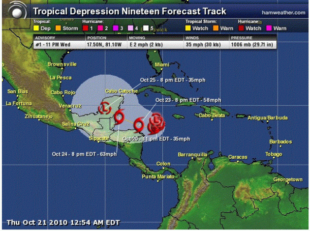
TD 19 as of 10 PM Wednesday
NHC track as of 10 PM Wednesday Night

TD 19 has also formed, and while I haven’t talked tropics a lot, we need a reminder that Tropical Season ain’t over yet. Right now the forecast track from the NHC has it becoming a tropical storm (Richard) over the next few days before taking aim on the Yucatan by the end of the weekend.


Model runs on this storm

I show you these spaghetti model to show that they aren’t all aligned with each other as of yet. The scary one would be the one that aims it toward Tampa by the beginning of next week.

This is a close up of that one model that has aim at Tampa — showing a strong hurricane by Monday evening in this area. I do NOT think this will happen — I have a big hunch that the path toward the Yucatan will be the correct track of the storm — but anything could happen.

Wind Advisory thru 7 PM

URGENT – WEATHER MESSAGE
NATIONAL WEATHER SERVICE TWIN CITIES/CHANHASSEN MN
341 AM CDT WED OCT 20 2010

…STRONG NORTHWEST WINDS TO DEVELOP THIS AFTERNOON…

.A COLD FRONT WILL BE SURGING SOUTHEAST INTO MINNESOTA TODAY…
REACHING THE SOUTHERN PART OF THE STATE THIS AFTERNOON. EXPECT AN
INCREASE IN NORTHWEST WINDS WITH THE COLD FRONT…BEGINNING
FIRST IN WEST CENTRAL MINNESOTA…AND THEN SPREADING SOUTHEAST
DURING THE AFTERNOON. SUSTAINED WIND SPEEDS WILL BE AROUND 30 MPH
WITH A FEW HIGHER GUSTS TO NEAR 40 MPH. A WIND ADVISORY IS IN
EFFECT THIS AFTERNOON FOR AREAS WEST OF A LINE FROM LONG
PRAIRIE…TO ST CLOUD…TO WASECA.
DOUGLAS-TODD-STEVENS-POPE-STEARNS-LAC QUI PARLE-SWIFT-CHIPPEWA-
KANDIYOHI-MEEKER-YELLOW MEDICINE-RENVILLE-MCLEOD-SIBLEY-REDWOOD-
BROWN-NICOLLET-LE SUEUR-WATONWAN-BLUE EARTH-WASECA-STEELE-MARTIN-
FARIBAULT-FREEBORN-
INCLUDING THE CITIES OF…ALEXANDRIA…LONG PRAIRIE…MORRIS…
GLENWOOD…ST. CLOUD…MADISON…BENSON…MONTEVIDEO…WILLMAR…
LITCHFIELD…GRANITE FALLS…OLIVIA…HUTCHINSON…GAYLORD…
REDWOOD FALLS…NEW ULM…ST. PETER…LE SUEUR…ST. JAMES…
MANKATO…WASECA…OWATONNA…FAIRMONT…BLUE EARTH…ALBERT LEA
341 AM CDT WED OCT 20 2010

…WIND ADVISORY IN EFFECT FROM NOON TODAY TO 7 PM CDT THIS
EVENING…

THE NATIONAL WEATHER SERVICE IN TWIN CITIES/CHANHASSEN HAS ISSUED
A WIND ADVISORY…WHICH IS IN EFFECT FROM NOON TODAY TO 7 PM CDT
THIS EVENING.

* TIMING…BEGINNING FIRST IN WEST CENTRAL MINNESOTA AROUND
NOON…THEN REACHING SOUTH CENTRAL MINNESOTA BY MID AFTERNOON.

* WINDS…NORTHWEST AROUND 30 MPH WITH A FEW GUSTS TO 40 MPH.

* IMPACTS…BRIEF DIFFICULT DRIVING ALONG WEST-EAST ROADS. SMALL
OBJECTS MAY BE BLOWN AROUND.

PRECAUTIONARY/PREPAREDNESS ACTIONS…

A WIND ADVISORY MEANS THAT WINDS OF 30 TO 35 MPH ARE EXPECTED.
WINDS THIS STRONG CAN MAKE DRIVING DIFFICULT…ESPECIALLY FOR HIGH
PROFILE VEHICLES. USE EXTRA CAUTION.