St. Cloud Area Weather

Highlighting important St. Cloud MN area weather events.

Monthly Archives: June 2010

Trying to Reason With Hurricane Alex, Early Wednesday Evening Edition

Quick update on Alex. He became a hurricane as of the 10 PM update last night, and has strengthened into a Category 2 storm throughout the day today. This makes him the first June hurricane since 1995, and the strongest June Atlantic hurricane (950mb) in over 50 years. The last one that was stronger was Audrey in 1957 (946mb). We expect landfall to be made in northern Mexico within the next few hours, and some more quick strengthening of the system is possible. This storm is a beauty on satellite, and with the pressure as low as it is, should be a higher category storm if it weren’t for the winds. Will continue to monitor the latest on Alex.


Read more of this post

“Trying To Reason With Hurricane Season”: Tropical Storm Alex, mid afternoon Tuesday

Quick update here from WeatherNation. Alex continues to be a Tropical Storm with winds of 70 mph, but greatly looks like a hurricane on satellite. Current forecasts have Alex making landfall just south of the Texas/Mexico border sometime Wednesday Night as a Category 1 hurricane with winds around 90 mph, but Alex sped up this morning to around 12 mph and if continues at this rate it could make landfall mid afternoon Wednesday. Hurricane Warnings are out from Baffin Bay, TX, and southward through Mexico. Update again later tonight as we are “trying to reason with hurricane season” along with you!


Read more of this post

“Trying To Reason With Hurricane Season”: Tracking Tropical Storm Alex, Monday Night Edition

We are closely watching the path of Tropical Storm Alex. After exiting off the Yucatan Peninsula yesterday better organized that it was as it entered, it is spinning around in the southwestern Gulf of Mexico. Currently the expected path has the system making landfall as a Category 1 or 2 system around the Texas/Mexico border late week. One key component to the track is a system in the Midwest that, depending on it’s deterioration, could send Alex even more northward. The good news right now is that, besides surf and a heck of a lot of rain (NOLA could pick up over 6″ of rain), this does not look like it should have a great impact of the oil spill efforts, and that the models have this storm pretty steady around the border. Of course, any storm in the Gulf is going to have an impact on the oil spill, which we will have to watch. We will bring you the latest as necessary. Just like Jimmy Buffett song says, we are “trying to reason with hurricane season”!


Read more of this post

Tracking Three Tropical Systems, World Cup, and the Severe Potential

Below is a post I wrote for the Ham Weather Biosphere Blog this morning that covers our three tropical systems in the Atlantic/Pacific, weather for the World Cup, and severe potential for the next few days over the US.

Read more of this post

(Cancelled at 537p) SEVERE THUNDERSTORM WARNING FOR STEARNS until 6 PM

…THE SEVERE THUNDERSTORM WARNING FOR CENTRAL STEARNS COUNTY IS
CANCELLED…

THE STORM WHICH PROMPTED THE WARNING HAS WEAKENED…HOWEVER SMALL
HAIL IS STILL POSSIBLE WITH THIS THUNDERSTORM.

A TORNADO WATCH REMAINS IN EFFECT UNTIL MIDNIGHT CDT.

Read more of this post

New SEVERE THUNDERSTORM WARNING for Stearns, Sherburne until 5 PM

BULLETIN – IMMEDIATE BROADCAST REQUESTED
SEVERE THUNDERSTORM WARNING
NATIONAL WEATHER SERVICE TWIN CITIES/CHANHASSEN MN
405 PM CDT FRI JUN 25 2010

THE NATIONAL WEATHER SERVICE IN THE TWIN CITIES HAS ISSUED A

* SEVERE THUNDERSTORM WARNING FOR…
SOUTHERN STEARNS COUNTY IN CENTRAL MINNESOTA…
SHERBURNE COUNTY IN CENTRAL MINNESOTA…
NORTHERN WRIGHT COUNTY IN CENTRAL MINNESOTA…

* UNTIL 500 PM CDT

* AT 404 PM CDT…RADAR INDICATED A SEVERE THUNDERSTORM…CAPABLE OF
PRODUCING QUARTER SIZE HAIL AND DAMAGING WINDS IN EXCESS OF 60 MPH.
THIS STORM WAS LOCATED 4 MILES EAST OF ST NICHOLAS…OR ABOUT 14
MILES SOUTHWEST OF ST CLOUD…AND MOVING EAST AT 45 MPH.

LOCATIONS IN THE WARNING INCLUDE…
ST CLOUD…
KIMBALL…
PLEASANT LAKE…
LUXEMBURG…
WAITE PARK…
SOUTH HAVEN…
FAIRHAVEN…
ST AUGUSTA…
CLEARWATER…
CLEAR LAKE…
HASTY…
ENFIELD…

PRECAUTIONARY/PREPAREDNESS ACTIONS…

IF YOU ARE IN THE PATH OF THIS STORM…PREPARE IMMEDIATELY FOR
DAMAGING WINDS IN EXCESS OF 60 MPH AND LARGE HAIL. SEEK SHELTER NOW
INSIDE A STURDY STRUCTURE AND STAY AWAY FROM WINDOWS.

SEVERE THUNDERSTORMS CAN PRODUCE TORNADOES WITH LITTLE OR NO ADVANCE
WARNING. PREPARE TO MOVE TO A PLACE OF SAFETY IN A STURDY STRUCTURE
SUCH AS A BASEMENT OR SMALL INTERIOR ROOM IF A TORNADO IS SPOTTED.

A TORNADO WATCH REMAINS IN EFFECT UNTIL MIDNIGHT CDT SATURDAY MORNING
FOR SOUTHERN MINNESOTA AND WEST CENTRAL WISCONSIN.

SEVERE THUNDERSTORM WARNING for Stearns (to our south and west) until 430 PM

*Check out post below this — TORNADO WATCH issued just to our south and east*

BULLETIN – IMMEDIATE BROADCAST REQUESTED
SEVERE THUNDERSTORM WARNING
NATIONAL WEATHER SERVICE TWIN CITIES/CHANHASSEN MN
331 PM CDT FRI JUN 25 2010

THE NATIONAL WEATHER SERVICE IN THE TWIN CITIES HAS ISSUED A

* SEVERE THUNDERSTORM WARNING FOR…
SOUTHERN STEARNS COUNTY IN CENTRAL MINNESOTA…
SOUTHEASTERN POPE COUNTY IN WEST CENTRAL MINNESOTA…
NORTHERN KANDIYOHI COUNTY IN CENTRAL MINNESOTA…
NORTHEASTERN SWIFT COUNTY IN WEST CENTRAL MINNESOTA…
NORTHWESTERN MEEKER COUNTY IN CENTRAL MINNESOTA…

* UNTIL 430 PM CDT

* AT 327 PM CDT…RADAR INDICATED A SEVERE THUNDERSTORM…CAPABLE OF
PRODUCING QUARTER SIZE HAIL AND DAMAGING WINDS IN EXCESS OF 60 MPH.
THIS STORM WAS LOCATED 8 MILES SOUTHWEST OF BROOTEN…OR ABOUT 15
MILES SOUTHEAST OF GLENWOOD…AND MOVING EAST AT 40 MPH.

LOCATIONS IN THE WARNING INCLUDE…
BELGRADE…
GEORGEVILLE…
HAWICK…
LAKE HENRY…
PAYNESVILLE…
ROSCOE…
MANANNAH…
EDEN VALLEY…
RICHMOND…
ST NICHOLAS…
COLD SPRING…
BROOTEN…

PRECAUTIONARY/PREPAREDNESS ACTIONS…

IF YOU ARE IN THE PATH OF THIS STORM…PREPARE IMMEDIATELY FOR
DAMAGING WINDS IN EXCESS OF 60 MPH AND LARGE HAIL. SEEK SHELTER NOW
INSIDE A STURDY STRUCTURE AND STAY AWAY FROM WINDOWS.

SEVERE THUNDERSTORMS CAN PRODUCE TORNADOES WITH LITTLE OR NO ADVANCE
WARNING. PREPARE TO MOVE TO A PLACE OF SAFETY IN A STURDY STRUCTURE
SUCH AS A BASEMENT OR SMALL INTERIOR ROOM IF A TORNADO IS SPOTTED.

&&

LAT…LON 4552 9432 4524 9446 4538 9533 4554 9529
TIME…MOT…LOC 2031Z 273DEG 36KT 4545 9520
WIND…HAIL 60MPH 1.00IN

TORNADO WATCH until midnight *just* to our south

This tornado watch is just to our south until midnight, but bears close watch since we are in such proximity of the watch box (my theory — within a county or two of the watch, count yourself under it too).
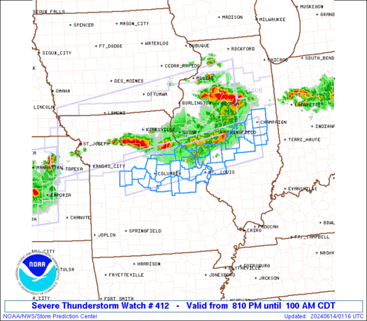
URGENT – IMMEDIATE BROADCAST REQUESTED
TORNADO WATCH NUMBER 412
NWS STORM PREDICTION CENTER NORMAN OK
335 PM CDT FRI JUN 25 2010

THE NWS STORM PREDICTION CENTER HAS ISSUED A
TORNADO WATCH FOR PORTIONS OF

NORTHERN IOWA
SOUTHERN MINNESOTA
EASTERN SOUTH DAKOTA
WESTERN WISCONSIN

EFFECTIVE THIS FRIDAY AFTERNOON FROM 335 PM UNTIL MIDNIGHT CDT.

TORNADOES…HAIL TO 4 INCHES IN DIAMETER…THUNDERSTORM WIND
GUSTS TO 80 MPH…AND DANGEROUS LIGHTNING ARE POSSIBLE IN THESE
AREAS.

THE TORNADO WATCH AREA IS APPROXIMATELY ALONG AND 80 STATUTE
MILES NORTH AND SOUTH OF A LINE FROM 35 MILES WEST SOUTHWEST OF
BROOKINGS SOUTH DAKOTA TO 40 MILES EAST NORTHEAST OF ROCHESTER
MINNESOTA. FOR A COMPLETE DEPICTION OF THE WATCH SEE THE
ASSOCIATED WATCH OUTLINE UPDATE (WOUS64 KWNS WOU2).

REMEMBER…A TORNADO WATCH MEANS CONDITIONS ARE FAVORABLE FOR
TORNADOES AND SEVERE THUNDERSTORMS IN AND CLOSE TO THE WATCH
AREA. PERSONS IN THESE AREAS SHOULD BE ON THE LOOKOUT FOR
THREATENING WEATHER CONDITIONS AND LISTEN FOR LATER STATEMENTS
AND POSSIBLE WARNINGS.

OTHER WATCH INFORMATION…CONTINUE…WW 411…

DISCUSSION…SVR TSTM POTENTIAL FCST TO INCREASE RAPIDLY OVER
WRN/CENTRAL PORTIONS OF WW AREA THROUGH REMAINDER
AFTERNOON…EXPANDING/SPREADING EWD. INITIALLY SUPERCELLULAR
CONVECTIVE MODE MAY TRANSITION UPSCALE TO DAMAGING MCS…PER
MESOSCALE DISCUSSION 1123.

AVIATION…TORNADOES AND A FEW SEVERE THUNDERSTORMS WITH HAIL
SURFACE AND ALOFT TO 4 INCHES. EXTREME TURBULENCE AND SURFACE
WIND GUSTS TO 70 KNOTS. A FEW CUMULONIMBI WITH MAXIMUM TOPS TO
600. MEAN STORM MOTION VECTOR 28025.

Severe Weather Watch (Tornado?) Possible Within Next Few Hours

The Storm Prediction Center is watching areas in southern MN, especially to the south, for the possibility of a watch in the coming hours. The main threats will be tornadoes and hail in the early storms that form, that will gradually turn to a mainly damaging wind event as we go through the evening hours. Heavy rainfall will also be a concern in any storm along with lightning. Keep you updated as we learn more.

MESOSCALE DISCUSSION 1123
NWS STORM PREDICTION CENTER NORMAN OK
0244 PM CDT FRI JUN 25 2010

AREAS AFFECTED…PORTIONS ERN SD…SRN MN…EXTREME NWRN IA.

CONCERNING…SEVERE POTENTIAL…WATCH LIKELY

VALID 251944Z – 252145Z

WW PROBABLY WILL BE NEEDED DURING NEXT COUPLE HOURS OVER THIS
REGION…COVERING INCREASING POTENTIAL FOR SVR BEGINNING INVOF ERN
LOBE OF CATEGORICAL MDT-RISK AREA IN DAY-1 OUTLOOK. INITIAL THREAT
IS FOR SUPERCELL MODES WITH POTENTIAL FOR TORNADOES…DAMAGING HAIL
AND SVR DOWNDRAFTS. HEAVY PRECIP WITH 2-3 INCH/HOUR RAIN RATES ALSO
IS LIKELY. UPSCALE GROWTH TO LARGER COMPLEX OF SVR TSTMS IS FCST
WITHIN A FEW HOURS THEREAFTER…WITH THREAT SHIFTING EWD ACROSS SRN
MN.

SFC MESOANALYSIS SHOWS LOW MOVING EWD ACROSS CENTRAL SD…ROUGHLY
BETWEEN PIR-HON…AND CORRESPONDING CLOSELY TO CENTROID OF CYCLONIC
CURVATURE EVIDENT IN VIS ANIMATIONS OF CUMULIFORM FIELD THAT HAS
THICKENED OVER SERN SD. RELATED MAX IN LOW-LEVEL CONVERGENCE…IN
TANDEM WITH SFC DEW POINTS UPPER 60S/LOW 70S F…AND SUSTAINED SFC
HEATING IN WRN PORTION OF LOW-CLOUD FIELD…SHOULD WEAKEN CINH AND
CONTRIBUTE TO TSTM DEVELOPMENT OVER THIS AREA. WITH MLCAPE APCHG
5000 J/KG…DEVELOPMENT MAY BE EXPLOSIVE WITH RAPID INTENSIFICATION
TO SVR LEVELS. WEAK WARM-FRONTAL ZONE…REINFORCED OVER NERN SD AND
SRN NM BY OUTFLOW FROM EARLY-MORNING COMPLEX…MAY MOVE NWD SLIGHTLY
AMIDST PERSISTENT AREA OF PRESSURE FALLS THAT HAS BEEN EVIDENT ALONG
AND TO ITS N OVER PAST 3-4 HOURS. RELATIVELY BACKED WINDS IN/NEAR
BAROCLINIC ZONE SHOULD ENHANCE LOW-LEVEL HODOGRAPHS…CONTRIBUTING
TO 100-300 J/KG EFFECTIVE SRH…AMIDST 40-50 KT EFFECTIVE SHEAR
MAGNITUDE.

*Moderate Risk*: Tornadoes, Hail, Wind today… More Severe Tomorrow?

I have to make this a quick post before I head out to work, but we do have a MODERATE RISK of Severe Storms over the area today. We are looking at storm initiation in the late afternoon hours to our west, with tornadoes and very large hail possible in the first few hours of it, before this forms into what we call a mesoscale convective system — simplest terms would beĀ  a bowing line of storms — and brings a mainly damaging wind threat with it. This is not set up exactly like last Thursday but the areas in southern MN that was affected last week are just about the exact areas that could see it again. We are also looking at another severe threat tomorrow — more on that later. Stay aware of the weather situation as we go through the afternoon and evening — will update as I can. Below is the convective outlook, you can check out the tornado, hail, and wind threats here.